


)

Perth – Built on lakes and wetlands
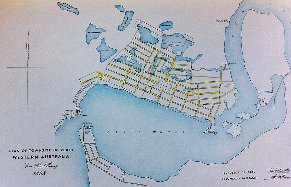
Perth city was established as a British colony in 1829. The street plan for the city centre was drawn up on a desk in London with almost no consideration given to the fact that the site was covered in a collection of fresh-water wetlands, swamps and lakes. They were known as Perth Wetlands, Perth Great Lakes or the Great Lakes District.
Whadjuk Noongar have lived on this land and been connected to country for over 40000 years with the wetlands providing a critical source for food and fresh water. No consideration was given to the impact that settlement would have on the local population either.
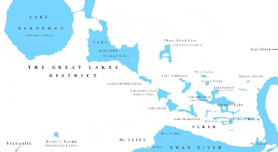
Most of the wetlands were reclaimed for market gardens, parks, housing or infilled due to an influx in water-borne disease caused by effluent pollution. Some also became nothing more than a drain. The lakes were located in the suburbs of Perth, West Perth, East Perth, North Perth, Northbridge, Highgate, Leederville, West Leederville, Wembley, Glendalough and Mt. Hawthorn. Over all, the hydrology of the Perth metropolitan region has a large number of lakes running parallel to the coastline north and south of the city, however the waterbodies known as Perth Wetlands referred to run out to the Swan River at Claisebrook Cove, opposite Perth Stadium.
Survived:
| Name | Former Name | Noongar Name |
|---|---|---|
| Lake Herdsman | Great Lake | Ngurgenboro |
| Lake Monger | Triangle Lake | Keiermulu |
| Claisebrook | Clause’s Brook | Goongoongup |
| Walter’s Brook | ———– | Warndoolier |
| Smith’s Lake | Three Island Lake | Danjanberup |
| Hyde Park Lakes | Third Swamp | Boojamooling |
Lost
| Tea-tree Lake |
| Lake Kingsford |
| Stone’s Lake |
| Lake Poulett |
| Lake Thomson |
| Lake Henderson |
| Lake Georgianna |
| Lake Irwin |
| Lake Sutherland |
| Second Swamp |
The Western Australian Museum provides further online resources to assist with the study of the Perth wetlands.